

ABOUT
The presence of Marine Litter (ML) has been recognized as a significant environmental problem, as it can dramatically affect flora and fauna and produce severe economic impact on coastal communities, tourism, and fisheries. Existing data collection and monitoring systems are limited and unable to respond to this spatiotemporal change and the dynamics of their concentrations in the marine and coastal environment. In this context, SciDrones P.C., a Spin Off company of the University of the Aegean that was created by members of the Marine Remote Sensing Group (MRSG) of the Marine Sciences department, has created the Coastal Marine Litter Observatory (CMLO). CMLO is platform which detects, maps and monitors marine litter in the coastal zone with the combined use of Unmanned Aerial Systems (UAS) and machine learning.
CMLO aims to improve the detection and mapping of marine litter in the coastal zone. The results presented through CMLO are open through a dedicated geospatial portal. In the CMLO system, the detection of marine debris in the coastal zone is visualized as density maps. The system provides functionalities for interaction with the results of the detection for every beach that is monitored.
WHY?
Today the mapping protocol of the marine litter in the coastal environment is carried out by using conventional on-site sampling. Existing data collection systems have limited ability to spatially display the concentrations of marine waste in the coastal zone. On the contrary, the use of UAS allows wide area coverage, provides the actual litter evidence (through high-resolution aerial images), and repeatability with low cost. Aerial imagery, in combination with machine learning methods, composes an automated procedure of locating and mapping marine litter in the coastal area.
DATA & METHODS
The detection of coastal marine litter using UAS data combined with the application of machine learning methods is an important step towards an automated process of detecting and mapping litter concentrations.
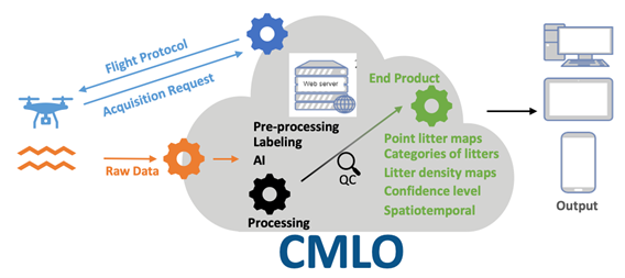
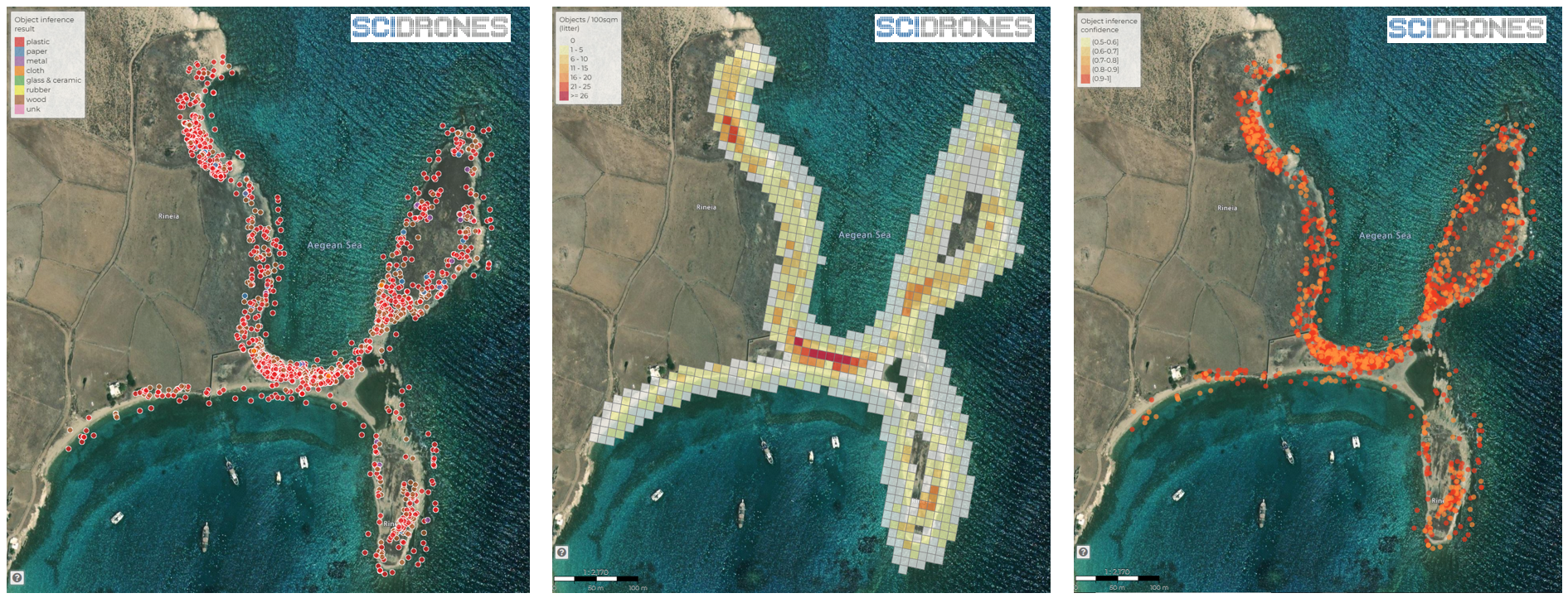
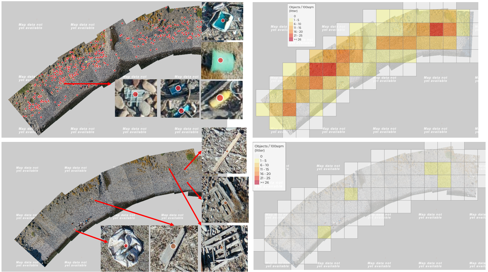
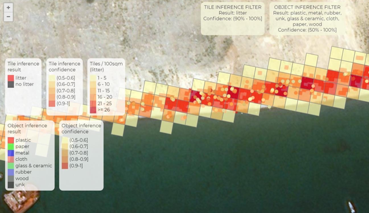
The methodology includes collecting high-resolution aerial photographs from UAS in a predefined method (SciDrones flight protocol) and by using machine learning algorithms to detect marine litter. The result is the production of density maps of marine litter in the coastal zone. In addition, CMLO can detect and map 7 different categories of marine litter materials. These are plastic, paper, metal, cloth, glass & ceramic, rubber, and wood.
The classification process results are visualized as density maps using a 10x10 meter grid following harmonized EU visualization methods. The density maps represent the number of tiles containing litter per 100 square meters, thus producing the density of litters into the area of interest.
SERVICE
The Coastal Marine Litter Observatory is an online web platform that is used in order to upload UAS aerial images collected using the data acquisition protocol developed by SciDrones. In the CMLO app, the user uploads data, and an automated process using deep learning algorithms produces an interactive report that depicts the results of the automatic detection of marine litter as density maps.
Within the Coastal Marine Litter Observatory (CMLO) the detection of marine litter results is visualized as density maps. CMLO includes all the derived information as geospatial information related to:
- Densities of plastic litter on various beaches across the world
- Plastic waste density maps per area of interest
- Spatiotemporal visualizations of plastic litter per area of interest
The CMLO is a tool for the quantitative presentation of marine litter distribution in the coastal zone using automated classification methods. In the CMLO app, users can interact and compare the marine litter detection results for every beach monitored.
CMLO and the produced marine litter density maps can be used as a decision-making tool for policymakers and scientists. The integration and visualization of the litter density information facilitate decision-making by stakeholders. Last but not least, the litter density maps and their spatiotemporal analysis are provided open to the public and organizations (NGOs, Local authorities, Governments, researchers, etc.).
SDG CONNECTION
UNDP SDG
SDG 14
GPML
EMODnet
SDG 14.1.1
(Index of coastal eutrophication and floating plastic debris density)
CMLO is ideal for the UN SDG Indicator 14.1.1b i.e. monitoring marine plastic litter in the beaches.
CONTACT
SciDrones P.C. is a spin-off company from the University of the Aegean (2022). It is a private startup company located in Lesvos Island, Greece, founded in 2021, by a team of experts in coastal mapping. The founders have vast experience in remote sensing, geoinformatics, and Unmanned Aerial System (UAS) technologies. SciDrones is a natural result of 7 years of intensive research on UAS technology and visualization of the geoinformation in the coastal area.
SciDrones’ main business focus is the mapping and quantifying of emerging coastal phenomena through state-of-the-art sensors. Quantification includes artificial intelligence algorithms and dedicated spatiotemporal visualizations. SciDrones analytical tools transform remote sensing data into real Information that drives decision-making.
Tel: +30 2251036786
Email: info@scidrones.com
Address: Vareia 0, University Hill, 81100, Mytilene, Greece